Dr. Abraham Gesner, Provincial Geologist, visited Grand Manan Island in 1839 to do a geological survey. He found the eastern section is of much older meta-sedimentary rock while the western section is younger (Triassic) lava called Dark Harbour Basalt Geology Map. The geological contact (a fault) can be seen at Red Point (elsewhere it is covered by soil and glacial deposits). From the parking area, a path leads to the west and onto the beach. Walk westward below a cottage to a point where a small brook runs off the cliff (this may dry up in some summers) and large trees begin. You will find the two geological eras clearly visible in the cliff face. To the left of the sloping fault line, you see dark grey lava rock (Triassic) that has been drag-folded; to the right of the line you see the older red and green rock (Cambrian argillite). With the use of a magnet, you can collect magnetite from the sand on the beach.
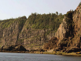
The western side of the island has high cliffs, 70-110 m (220-350 ft) high, mainly composed of one immense lava flow – see it at Southwest Head. At Seven Days Work are 7 to 12 thinner flows that overlie the Southwest Head member, and the Ashburton Head member is a thick lava flow that caps the entire package. They flowed as a great “flood basalt” with a catastrophic effect on the environment that helped to cause a mass extinction at the end of the Triassic Period.
Glaciation has also left its mark with gravel and sand deposits, and glacial erratics – large granitic boulders scattered about the island including an interesting site: The Upper and Lower Flocks of Sheep near Deep Cove. Changing sea levels has alternately left beaches exposed or submerged. Tidal currents and storm waves have created large barriers or “barachois” (gravel, rock and boulder bars with water trapped on one side) on the western side of the island. The largest forms Dark Harbour Pond. Smaller versions are present at Long Eddy Point, Indian Beach, and Money Cove along the western shoreline.
Geological features have given rise to some local names: White Head with its white quartzite head land, Seven Days Work – a cliff face with layers of lava flows, the Bishop – a rock pinnacle on the northern end of the island, and the marvelous Hole in the Wall, a “flying buttress” arching out from the cliff near Fish Head. Ongoing erosion is constantly changing the shape of the archipelago (beaches, ledges, cliffs, etc.), exposing 3000-year-old tree roots and stumps in some places.
Rock hounds can find jasper, agate, amethyst, and zeolites with a little searching. Native copper can be found near Whale Cove (a copper prospect was opened at Sloop Cove in 1872). A marble deposit on Kent Island extends 201 m (660 feet). Several “traprock” quarries provide stone and gravel for local construction.
The Grand Manan Museum has a new geology exhibit where you can see examples of local rocks and minerals, and posters explaining island features. Also see this Grand Manan Geology web page.
Have a Question? E-Mail us at: info@grandmanannb.com